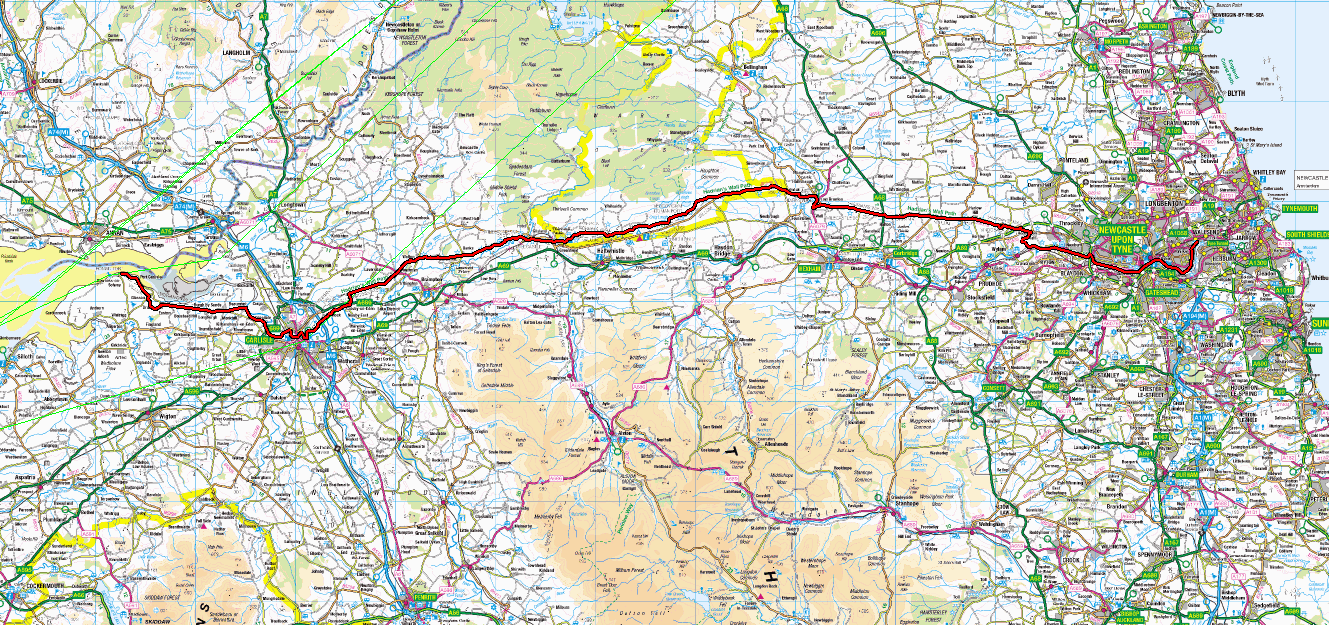
Hadrian's Wall Path
Bowness-on-Solway to Wallsend in Newcastle 84miles (without diversions).
19/8/2005 to 27/8/2005
| Photos |
| Locations |
 Route Information
19/8/05
It's raining! First day of a week’s walking and we wake to a thunderstorm... We wait but it
shows no sign of abating so the plan to walk to the station is abandoned in favour of a taxi
ride. Taxi driver is happy at any rate as the rain makes sure he is busy. It's an ill wind...
We catch the train from Grays to Fenchurch Street, drawing curious stares due to our rather
out of place walking gear and rucksacks.
The Circle Line is working again, congratulations London Transport and may the bombers rot in hell. Not surprisingly Euston is full of police, but the atmosphere is relaxed and friendly. We board the rather crowded 11.45 to Glasgow and we are finally properly on our way.
I am at this point a little disturbed. I had booked First Class tickets (good value at £30 each), we were in the correct carriage, but it had been "declassified". There goes the free food and drink, thinks I. Fortunately when our tickets are checked we are moved into relative luxury. When we asked for a glass of wine we were given "the rest of the bottle" (a rather nice white Rioja), looked like it was missing one glass. This is the way to travel! These trains are fast, and we arrive in Carlisle at 15.40, explore briefly then catch the No: 93 from the bus station at 16.30 and arrive in Bowness-on-Solway around 17.25. The helpful driver dropped us outside our accommodation for the night (King's Arms Hotel) and we literally stepped off the bus and through the door.
Bowness is a quiet town at the west end of Hadrian's Wall built within the confines of a Roman fort. The fort is not extant, as the material was used to build the town, as is often the way. It doesn't take long to explore, there are some interesting buildings and a forgotten footpath that leads to the seawall and a ladder down to the Solway. Walking East brings you to the start of the way in a pleasant garden built with aid from the Heritage Lottery Fund.
The food is simple but tasty and the beer is good. The staff are friendly and helpful, the patrons welcoming. There is a pool table and a darts board. Considering James learned his pool via the internet he did pretty well. Darts, well, a little practice will sort that. We were tired so collapsed early in our room, which was clean and comfortable.
20/8/05
Awake at 05.30, 06.30 and 07.30. Guess it's time to get up then. We won't talk about Jamie's
snoring, it’s not his fault. There's a dawn chorus outside the bathroom, someone keeps
parakeets... Breakfast is standard bacon and eggs etc. Well-cooked and tasty. We repack,
slowly, it will get faster as the week goes on. We pay (good value) and leave for our first
days walk.
Starting from the Roman herb garden we walked along the coast to Port Carlisle. The old harbour walls are broken, the harbour itself is silted up, as is the waterway leading in from the south. We continue SE along the coastal road then turn inland towards Glasson, passing the interestingly named Highland Laddie Inn before turning East towards Drumburgh and a fine fortified house. There follows a five mile road walk which is mildly tedious but you can walk along what is, I think, the Vallum.
There is an interesting church in Burgh by Sands, rather square and blocky. After Burgh by Sands you leave the road and cross fields to Beaumont following an old drover's road. We met one man and his dog. His dog was carrying a set of panniers. "If he wants to come with me, he needs to carry his own stuff". There is then a river walk, followed by a short climb into Kirkandrews-on-Eden before crossing fields into Grimsdale.
Lunch was above the river. We had fine views to the east. My rucksack at this point fell over into a fresh cowpat. Fortunately fresh cowpat is relatively non-sticky and on lifting the rucksack it was remarkably clean! We then stuck to the river in rather up and down fashion (stairs - we ran up to prove we could - fools) until we got to Carlisle. It was in the outskirts of Carlisle that I realised I had a blister developing at the base of my big toe. A repair stop fixed that but on standing I realised the weight of my pack was telling a bit, so I swapped with son James to take the pressure off.
We then crossed the River Caldew (and the Cumbria Way) and shortly after arrived at the Sands Sports Centre. The pedometer says 16 miles and the clock says 5 hours. The map measurer ays 14 miles, but experience says it's wrong (remeasured at 15.5 miles). After shopping for new inner soles (my feet hurt!) and another Leki pole (my knees hurt), some blister patches (Deb's feet hurt) and a tour of Carlisle Castle we had clocked up 20 miles on the pedometer before getting to the Angus Hotel (remeasured at 18 miles). A quick shower then down to the Bistro for a fine meal and a bottle of wine.
21/8/05
It's another beautiful day in the corps! Lovely sunny morning. Shorts today I think. Some
careful foot preparation required, but looking forward to climbing a little up the River
Irthing to Walton. Breakfast is an excellent blend of English and Continental. Probably ate
too much of course.
We found our way back to the river and the Sands Leisure Centre (which is a stamping point for your walk passport) and turned east between the river and a golf course.
The route is not so well marked when walking East. Just outside Carlisle where the route crosses a park towards football pitches it is not at all obvious that the route takes the middle of three paths. We took the left path initially, realising it was wrong when we got to the football pitch. Unfortunately some lads also doing the path, walked past us then turned left (incorrectly), we turned right and got back on the correct path. The next difficult spot is on a farm track. Where it forks, turn left, we found out the hard way....
There follows a slow climb up to Newton (max altitude around 60 meters) through fields generally full of cows. Sadly quite a bit of height is lost down into Walton mostly on stone steps. At one gate I had to push a horse out of the way as it was blocking the kissing gate. I am pretty allergic to these beasts and have only just stopped itching. More worryingly it nibbled at the mouthpiece of my platypus (water bottle) and my mouth reacted when I next took a drink. Damn allergies. In the next field, rather to our surprise was a bull, not a bullock, a bull. The huge bull was in the next field. No problem thinks I. Aha, there is an open gate between the two fields. Pain or no pain my pace went up....
Leaving this field we entered Walton and there is the Centurian Inn. What an excellent place. The pedometer says 14.5 miles, the map measurer 13 (rechecked 12.3 miles). The people are friendly, the beer is excellent and the menu looks fine. I can hear our washing going round as I type, most helpful. Sitting in the back garden I can see Cold Fell straight ahead. Tallest fell in the Northern Pennines. After a beer or two in the sun James went to chill and watch T.V.
Deb and I went for a walk around the village. Primitive Methodism is a new one on me. It's now a house rather than a church, which may say something. The more orthodox churchyard is full of sad stones "and .. 11 months and .. 4 months and .. 11 months" things have improved in that arena at least. To improve our mood we played on the swings and had a spin on the roundabout. Afterwards we dragged James from his room for a game of cards before dinner. We sit awaiting tonight's offering and the wine is cooling.... Not cooled enough but very tasty and the food was excellent. Hmm it's raining, time for bed said Zebedee.
22/8/05
Woken at 4am by the Inn sign banging in the wind, this doesn't auger well. 6.50 and it's time
to get up, there is to be a power cut at 8.30 so all actions requiring electricity are to be
done by then. It is grey and overcast, windy but at least it's not raining. Will need a few
more clothes today. Breakfast is at 7.30 no arguments. The saltiest fattest bacon I've had
for a long time, but the flavour is excellent.
I collect the washing, didn't realise we had so much, but at least we can dress and pack properly now. Unfortunately Deb is in a bit of a bother. She had a car accident a couple of days before we started so already had a stiff neck, this has been exacerbated by carrying a rucksack for the last couple of days. We give Deb Jamie's rucksack (already the lightest) and take some out and put it in mine. This gives her a reasonably light load. A bit of foot reconstruction and off we go.
We leave at 9am and arrive at Birdoswald Fort at 11.50. The pedometer says 7.5 miles, the map measurer says 6.5 miles. It's another up day today, pity it starts with a down to cross the beck at about 40m altitude. We see our first bit of Wall at Hare Hill at 130m. The sign says "thought to be the highest bit of wall" this confuses me until I realise they mean "tallest", however what can be seen was rebuilt in the 19th century.
Cold Fell to the South is our constant companion and is covered in cloud for the first couple of hours. By the time we reach the fort the sun is starting to break through and we have lost sight of the fell. The sections of wall and turrets are interesting but the most impressive sight (for me at least) are the earthworks that are most easily appreciated near Wall Bowers and Appletree.
We stopped at Birdoswald for coffee and ice cream before exploring the fort. An interesting place but it could do with more explanation of what some of the features are. Behind the fort the ground falls steeply away to the river affording fine views. Afterwards we returned to the cafe for lunch.
Leaving the fort we followed the wall east past milecastle 49 to the Willowford footbridge. We spent some time mucking about in the river and taking photos before moving on to Willowford Roman bridge. The river has changed course in the last 1800 years and much of the bridge is gone but the sluices remain obvious. We then jogged up the rise (yes, we are mad), well James and I did, and Deb followed slowly. We popped up into a farm through which we walked on the road rather than the path as it was blocked by sheep. There follows a gentle descent into Gilsland where we left the path to find our bed for the night in Howard House Farm. Pedometer says 10.7 miles to here map measurer says 8.5 miles (rechecked 8 miles).
A quick shower later we head down to the Samson Inn. We are a bit early so climb up to Lawn Top and the weather station. There are good views, east towards Thirlwall Castle and the "Nine nicks of Thirlwall", behind and northwest to Howard House and Orchard House. Back down from Lawn Top and west along the earthworks to the Samson Inn again. Friendly, good beer and simple but good food. It's getting chilly now so a brisk walk back to the house to relax before bed.
23/8/05
Another full English breakfast... I can feel my arteries furring up. Weather report not good,
but it looks great out just now so we are going to get out and enjoy it whilst we can. We are
packed and on our way by 09.30. Another up day starting with a down back into Gilsland to the
school where we left the route yesterday. There are impressive earthworks here amongst the
houses and we pass through two gardens, one with a large strawberry patch, the other full of
"gnomes" (well, comic strip figures pretending to be gnomes).
As we pass Thirlwall Castle we climb from 130m to 210m to join Walltown Crags, also known as Cragside, AKA 9 Nicks of Thirlwall. There are some good sections of Wall and some entertaining descents and ascents to 289m near Alloa Lea. It is very windy from here to Twice Brewed. I got a fly in my ear up here, I know this because I got half a fly out! There follows gentle descent into Aesica Fort. This is access land and is essentially an unexcavated farmer's field with some good sections of fort wall and buildings.
Cawfields appears to be a popular picnic spot with most people not straying far from their cars. From here there is a moderately stiff climb, initially to Shield on the Wall and then to a trig point at 345m North of Winshields PH. Running down is quick and easy, running up isn't. Hopefully I will be both fitter and lighter at the end of this walk.
From the trig point we descended to the minor road then walked down past Once Brewed to the Twice Brewed Inn. This is my third visit over the years, and it is definitely getting better. The pedometer makes it 9 miles to this point. We arrived at 2pm.
We arrived just in front of the rain, dumped our rucksacks then headed to Vindalanda Fort in the rain (about another 4 miles there and back - rechecked - total distance including Vindolanda 12.6 miles). Impressive place, run by a charity, not EH or NT for a change (which is a pity as it meant we had to pay to get in!). It is an extensive site, particularly interesting for me were the many examples of hypocaust (underfloor heating). The museum is extensive and educational, the letters are particularly fascinating. These Romans were well ahead of their time. Or looking at it another way seem to have had some rather poor centuries of decline before recovering to where we are. What did the Romans ever do for us?
24/8/05
It rained all night and blew very hard. It did not sound promising in the wee small hours of
the morning. It was still raining through breakfast and as we went to get ready to leave.
Consequently we exited the Inn in full wet weather gear and into windy but dry weather. Ah
well, leave it on it is chilly after all.
A brisk walk up from Twice Brewed takes us up the road then back on the Path up to Steel Rigg. It's windy up here but dry. After a mile of climbing to around 260m we were getting pretty warm and took off the wet weather gear. The high point was around 300m.
The ridge walk above Crag Lough, along Hotbank Crags then down to Housesteads is invigorating. Housesteads is relatively disappointing compared to other forts on the walk, but naturally remains interesting. It is quite extensive, but the remains are fairly low and some of the fine detail present in other forts is missing.
A brief down from Housesteads is followed by a good climb to the trig point at 325m on Sewingshields Crags. A little confusion ensued as we left Housesteads. I followed a young lady who looked like she knew what she was doing. At a gate unmarked by the ubiquitous acorn of the path I said "This is the route is it?", "Yes" was the reply. At the second unmarked gate it was clear this wasn't right. I dragged my troupe straight up the hill back to the correct path. The young lady took a lonely route along the vallum to Sewingshields where she expected to rejoin the route. We never saw her again, we assume she is ok! There followed a gentle ridgewalk down to the earthworks by the B6318.
The earthworks are mildly interesting in their own right, but walking by the B6318 is somewhat tedious. A detour (on the path) south of the road brought us to a temple where casts of the original finds were in place, they give a good feel for the structure as it would have been in Roman times.
Back on the North side of the road we pass through several fields with bulls in them. We are pretty used to this by now and our experience seems to bely the belief that red infuriates bulls. We made Deb wear red to test this theory, but nothing came of it.
A pretty unexciting walk brought us to Walwick and Chesters Fort. The last 3/4 of a mile or so were on the road, which was pretty harsh on the feet by that point. Chesters is amazing, though the museum is not as interesting as that at Vindolanda. The bath house down by the river is particularly impressive with tall walls and a lot of detail. The pedometer said 10.6 miles to this point, and we arrived at 3pm. The pedometer then suffered a dire fate at this point when Deb dropped it in the loo.... It is drying as I type to see if it recovers from this insult! After Chesters we had a naff road walk of around 1.5miles to The Crown pub in Humsaugh above Chollerton. The name "The Crown" should have forewarned us that it was at the top of a hill, just what you need at the end of the day! We arrived at 5.30 and the doors were shut despite the sign saying "Open all day", as it happens a staff member passed by and he got us in for a much needed shower. (Rechecked distance to this point including crawling all over Chesters - 12.5 miles).
We were down to the bar at about 6.30 and the bar and restaurant were full! If you stay here (and I recommend it) book the restaurant as you book your room. The staff are very friendly, the food is good (enormous portions!), the wine most drinkable and the beer ok.
25/8/05
It's a beautiful morning. Windy and scattered clouds but the sun is shining as we eat
breakfast. The cook can make excellent bacon, but that is only to be expected after the meals
last night, which had fine touches like sliced strawberries and dabs of fish roe in the salad.
He's a large, genial chap, who clearly enjoys his cooking. we left at 9.10am.
The sun was still out when we left, walking back down to Chollerford to rejoin the path. Before moving on we walked back towards Chesters on the other side of the river to look at and admire Chesters Bridge. Naturally the bridge is actually gone, but the base stonework remains and is impressive. We also had good views back across the water to the bathhouse.
We worked our way back to the path and got on our way. Initially there is a tedious road walk which takes about a mile to make less than half a mile of linear progress. The walk beside the B6318 to the Robin Hood PH at East Wall houses is about as good as it could be all things considered. For us this is 13 miles to this point. Around Carr Hill some earthworks liven things up a bit and it was something of a shame to see farm buildings straddling the earthworks. The maximum altitude to this point was 268m on Whittington Fell.
We spent an hour at the Robin Hood PH for lunch. The food was simple but generous, the beer was good but decidedly non-generous. They must have taken lessons on how to serve a short pint. I let it pass the first time, but the second I insisted on a top up. It was done but not with good grace and there was still much less than a pint of fluid, legal but only just. This was clearly going to be a long day, so James now took my pack (heaviest), Deb took Jame's (lightest) and I took Deb's.
The path after the pub was ok until Rudchester / Vindobala Fort. The fort was a disappointment, completely hidden under grass. After that the path was a rather unpleasant road walk into Heddon-on-the-wall. After a bit of confusion, we find our way down to Heddon Banks and our first view of Newcastle.
We now lost what remained of our altitude as we came down past a biological field station then across a golf course to the bank of the Tyne. There were still 2 miles left to Newburn and we didn't help ourselves by over shooting the Keelman Inn and having to walk back to it. We arrived at 6pm. 25 miles (rechecked distance 22 miles) by map measurer in just under 7.5 hours of walking. This may explain why our feet hurt! Dinner in the restaurant is good and filling. The beer comes in jugs with a free half pint and tastes excellent. Beginning to feel better! 25 miles seemed excessive, so I checked using someone else’s copy of Mark Richard's "Hadrian's Wall Path - A Cicerone Guide". According to this it is 20.25 miles from Chollerford to Newburn. Taking into account our stay in Humshaugh and our side trip to Chester Bridge the true distance is 23 miles.
26/8/05
It's another beautiful morning. How lucky is that? This is the first place we have stayed
where we had to let them know the day before that we wanted breakfast and have paid extra for
it. That aside it was good accommodation and very convenient to the route (once we knew where
it was - a sign would be helpful), it is about 40 yards North of the very large slipway at the
start of Newburn.
Sunny but cool so an extra layer today. The surface from here to Wallsend is unrelentingly tarmac and consequently relatively hard on the feet. The path makes the best of what is available, and trees screen the worst of the industrial landscape, but it does mean the view is very restricted. A diversion over a footbridge takes you over the A1 before returning South to follow the river.
The Heritage Trail near Elswick is interesting and well maintained. A convenient hotel makes a good coffee stop and it was amusing to watch businessmen negotiating deals while we relaxed. As the trail ends you get a brief moment when all 7 of the Tyne bridges in this area are visible.
St Peter's Basin is fairly attractive, but doesn't last long. Shortly after, however, there is the wooded area of Walker Riverside Park. The river is more attractive and less obviously industrial at this point. Sadly heavy industry is never far away and for the last couple of miles we are separated from the river by large buildings and massive cranes.
Arrival at Wallsend, the last scrap of wall and Segedunum in that order is something of an anticlimax, at least at Bowness they made an effort with the archway and the Roman herb garden. The museum is higher tech than any of the others but poorer in material and there is a paucity of extant stonework in the excavated fort. I buy my own copy of Hadrian's Wall Path by Mark Richards to cross check distances and read in more detail about some of the areas we have visited.
We arrived at 1.30pm, according to the book some 10 miles from Newburn. However, try as I might, I can't make it less than 12.5 miles (rechecked 12.2 miles). After a bite to eat and a bit of shopping we get a taxi to the Menzies Hotel, Silverlink Park. This is a 4 star hotel and was intended as a luxurious treat to end the holiday. All went well until after my shower I found the only (yes only) towel in a double room was covered in lipstick. Replacements were brought up quickly but still… Coffee after the shower, and what’s this one small pack of biscuits between the 2 of us, hmmm. Turn on the radiator to dry swimwear, it starts leaking, that’s that plan finished with. Well never mind, down to the bar for a drink. Some lads order some sandwiches and request cutlery “They’re ‘avin’ a laugh aren’t they?” quoth the barmaid. More hmmm.. I order drinks, £3.30 for a pint of lemonade, that does it and I complain to the manager. Promises a discount when we settle the bill.
27/8/05
The night is disturbed by drunks returning from the bar slamming the fire door outside our
room, then at 5am one particular moron sets off the fire alarm by smoking in his room. We get
downstairs to be told it’s a false alarm, not by a staff member – there are none to see, but
by a lady who is now locked out of her room. When we finally get up properly there are
silverfish in the bathroom… At breakfast one of the kitchen hands appears to be in a bit of a
mood and is slamming about, he knocks tongs onto the floor. Does he get clean ones? No, he
picks them up and puts them back for people to use getting their breakfast! Don’t think I will
ever stay here again.
We catch a taxi to the station then explore around the city walls and Chinatown before returning to catch our train. Standard class this time and what a difference. Cramped but not unbearable and we are soon back in London.
28/8/05
Today I bought a more accurate map measurer, an electronic one by Silva. I checked and
rechecked its accuracy before repeating my earlier measurements.
Distances include side trips and journeys to accommodation.
| King's Arms Hotel Bowness on Solway to the Angus Hotel Carlisle | 18 miles |
| Angus Hotel Carlisle to Centurian Inn Walton | 12.3 miles |
| Centurian Inn Walton to Howard House Gilsland | 8 miles |
| Howard House Gilsland to Twice Brewed Inn (via Vindolanda) | 12.6 miles |
| Twice Brewed Inn to Crown Inn Humshaugh (Chollerton) | 12.5 miles |
| Crown Inn Humshaugh (via Chesters Bridge) to Keelman Lodge Newburn | 22 miles |
| Keelman Lodge Newburn to Segedunum (Wallsend) | 12.2 miles |
| Total | 97.6 miles |