| 2020 to 2024 |
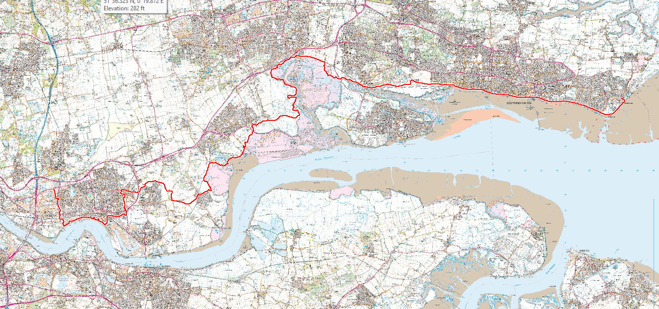
| 37 miles from Shoeburyness to Lakeside |
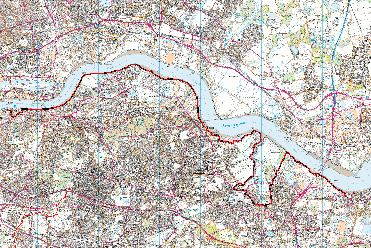
| 19 miles from Greenhithe to the Thames Barrier |
| Photos | Shoeburyness to Lakeside | Locations |
| Greenhithe to Thames Barrier | Locations | |
| Coalhouse Fort | Locations |
 |
 |
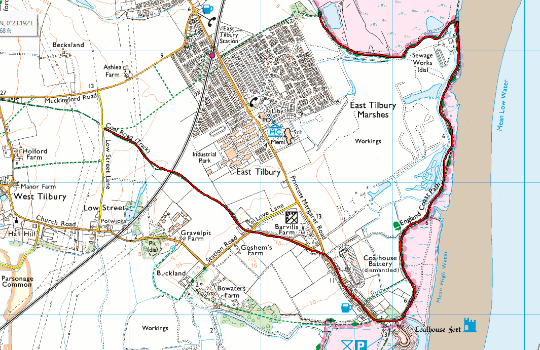 |
| Shoeburyness to Lakeside | Greenhithe to the Thames Barrier | East Tilbury to Low St Lane |
This section is very local to us and was consequently easy to complete on day trips. We explored roughly 200 miles of local paths in this time, many of which are very poorly maintained. The National Trails website gives the Thames path as finishing (or starting) at the Thames Barrier. However, these days the OS maps show it extending to Crayford Ness.
When we did the Thames Path, we started at the Thames Barrier. Approaching the Thames Barrier from the East really requires you to cross the river to reach the South bank as there is no reasonable route around the docks and industrial areas of Dagenham. Since the demise of the Tilbury ferry this really means crossing at the Dartford crossing. However, I will describe a route using the ferry as an alternative, as it is possible it may come back into use.
Shoeburyness to Benfleet Station is about 10 miles. From Shoeburyness Station as you walk SE towards the High St you will see a path the other side of the High St where an old siding or branch line crosses the road. Follow this path SE to the beach and the England Coast Path (ECP).
You can just follow the ECP all the way to Tilbury Ferry, however, we prefer to leave this path at Leigh-on-Sea station. At Essex Yacht Club, just before the station, you will see HMS Wilton. Cross the railway and go up Belton Way West. After about 150 yards there is an obvious path on the left, initially gravelled. There are a couple of parallel paths, one of which is the Saffron Way. These follow the north side of the railway. It is worth taking the Northerly of these paths as it climbs the ridge to Hadleigh Castle. There are ruins to explore and fine views.
After the Castle the path turns South (Castle Lane) back towards the railway, then West around Plumtree Hill. Where the Saffron Way turns North towards Sandpit Hill, continue West on the Poynets and Kersey footpath. This follows the Southern edge of Hadleigh Country Park, then the Benfleet Downs. Just as the railway starts turning Northwest the foot path crosses the railway and pops out onto Ferry Road. Just before Ferry Road passes under the railway, there is a path on the left. Follow this path, do not pass under the railway. You will find yourself back on the ECP.
You can just follow the ECP to Rookery Farm then Church Road, or you can take minor (and to us more interesting) paths to the West of Great Mussels, joing the ECP at Church Road. The ECP turns West at the Church, now on the North side of the railway. Continue to Pitsea and turn left down Pitsea Hall Lane. Take the second on the right after Pitsea Car Park, do not cross the railway at the crossing. It looks like an industrial area, but it is marked as the ECP.
As this lane meets the A13 the path crosses to the South side of the railway. The ECP now passes around Pitsea Marshes, Wat Tyler Country Park and Vange Marshes. Initially Westwards, then turning South. You can slavishly follow it all the way round to Corringham, however, in truth we didn't find it that entertaining so used a local path to cut off the loop opposite Fobbing Horse, then turned West on an obvious local path towards Fobbing. At Fobbing you turn right, then left to pass the Sports Ground and School to the South. If you find yourself at St Michael's Church in Fobbing, you've gone too far, but there is a path opposite the Church that brings you SW towards the Sports Ground.
There are, in fact two schools. The furthest south one can be passed on the south side, then turn NW towards Cobblers Mede Lake. Otherwise you can turn North up Herd Lane then turn left on the path immediately after the school. This will also pass Cobblers Mede Lake and will come out near The Bull pub. Carry straight on over Church Road to enter the Churchyard, there is an exit onto Rookery Hill. Turn South down Rookery Hill to the Manorway. Turn briefly NW, opposite the industrial unit cross the dual carriageway (easy) and rejoin the ECP. This way of doing things avoids quite a long walk alongside the Manorway and its traffic.
Follow the ECP along the Western edge of the London Gateway Logistics Park, passing Great Garlands Farm. Take the footbridge over the road then continue on the ECP past Stanford le Hope marshes, Mucking Flats and Mucking Marshes. At this point there are two choices:
A) If you want to visit Coalhouse Fort, then continue on the ECP to the Thames and follow the ECP South to the Fort. From here go up Princess Margaret Road, then turn left on Station Road. As this road swings round to the left past Love Lane, there is (immediately on the right / North) a track that looks like someone's driveway. It is that, but it is also the Southern End of the Coal Road. This is a very old road in slow decline. Continue up the Coal Road until Low Street Lane, crossing the railway en-route.
B) If you want to take a rather more direct route (and possibly keep your feet drier), then where the ECP meets a track from the West at a small wood, turn West. Pass through the wood then continue SW along the edge of the housing until meeting Princess Margaret Road at East Tilbury Station. Immediately after crossing the railway at the level crossing, turn sharply SW down a path that parallels the railway before poppoing out on a track. Follow this track SW across the field to meet the Coal Road at Low Street Lane.
Again at this point you have two choices:
A) This first route involves walking through horses and housing, and a couple of areas may feel uncomfortable to some. I know the area well and it is no problem for me. Turn South down Low Street Lane, then turn right on a track at a pylon that takes you to Blue Anchor Lane at Holford Farm. Turn South then West along Rectory Road to Turnpike Lane. Go striaght across, cross a stile and head SSW until you hit Biggin Lane. Continue down Biggn Lane to St Chad's Road where you turn right. At the roundabout cross Chadweel Hill, then cross the B149/ Chadwell Bypass at the pedestrian crossing. Here there is a footpath that goes up Hutts Hill, before turning West along the South Side of some housing. The path then turns North towards Crouch road (between houses), crosses Crouch Road and continue up to Riverview. Turn right on Riverview before turning North on a track at number 42. Follow this track North to the corner of Heath Road. Turn left (West) to a footbridge over the A1089.
B) Our preferred route. At Low Street Lane go NW, then WNW on the Coal Road meeting Muckingord Road at its junction with Blue Anchor Lane. Go North up Hoford Road, initiall tarmacced, it becomes gravelled beyond a gate. Follow this past the track to Becksland, turning left along the track due West to High House.Turn right up High House Lane. Follow this until the 3 tower blocks are lined up then turn towards them and you will come out on Brentwood Road. Cross this road and pass to the North of the housing to Old House Wood. Go WSW though the wood then follow the junction of two fields WSW then SW to a path that takes you South to Greyhound Lane. Turn right to Heath Road. Cross this road and head SW across the recreation ground to the footbridge over the A1089.
The paths have now converged. All of this is to get around Tilbury as the docks prevent you walking along the river. From the bridge go due West along the edge of a small wood, then past the Academy. The path is obvious, goes through some housing and crosses King Edward Drive to enter Hangman's Wood. Continue WNW through the wood to Daneholes Roundabout. The Daneholes are nothing to do with Danes and should be spelled Deneholes. They are actually medieval chalk pits and are an SSSI.
Cross Woodview by the underpass, turn SE then almost immediately right down the path by the roundabout sign. This takes you onto a green, go SE to exit on a path at the NE corner, popping out by number 27 on Ridgeway. Go South down Ridgeway to Chadwell Road, turn right then left into Grays New Cemetery. Exit at the Southern end then continue through the recreation ground to exit where Rookery Lane joins Marshfoot Road. Cross and go a short way down Old Dock Approach Road before turning right down the cycle path heading South. After about 250 yards turn right and skirt the housing whilst travelling West. Pass to the North of the school along Manor Road to continue down Grove Road to its junction with Bridge Road. Turn left down Bridge road and then continue on Manor Way until you enter Grays Beach Riverside Park.Go SW through the park to the river.
Follow the river West until you reach the obvious large factory of Proctor and Gamble. Here turn right on St Clement's Walk. This takes you up to St Clement's Road and Church (Four Weddings and a Funeral) which is worth a visit. The path used to continue North over the railway, but this is now closed sadly. Consequently you have to turn left on Hedley Avenue (path on South side) before turning North on the A1090 (path on both sides). Cross the roundabout to the right or left before continuing North on the West side of West Thurrock Way. You can walk up this road cross at the roundabout to the East side then cross the A126 to reach Lakeside, but there are six lanes of fast traffic. It is safe to do with patience, but not nice.
We prefer to turn right up a path after about 100 yards where there is an obvious crossing point. This takes you up to a track by the railway. Head North until it turns back on itself, briefly going South, by Chafford Station. Don't head back North, but go East to come round to the station entrance. Catch the X80 Bus to Bluewater shopping centre, getting off either at ASDA or Greenhithe Station.
From either of these stops go West along the North side of the A206 until turning right just after the ASDA slip road to head North on a path that takes you to the South bank of the Thames. The path entrance is marked by 2 blue posts. You are now back on the ECP and go West. Rather than slavishly following this path all the way round Dartford Marshes, we turn Southwest on a path just after the sewerage works.
The problem now is crossing the River Darent. This can only be done via the A206 or at Dartford Station. We really didn't fancy the A206 so headed for the station. The path that heads SW from the ECP is Marsh Street North. Where this street turns East, continue SW to come out on Binnie Rd. Turn right on Binnie Road, then immediately left on a path that winds between houses in a Southerly direction until meeting the Kent Fastway. Turn right and follow this road over the A206. Where the road meets Joyce Green Lane, turn right, then left to stay on the Lane. At the bollards turn left.
You are now on Central Road. You can follow this all the way to William Munday Way or Mill Pond Lane and turn right / West. However, we turned West at a public footpath sign between the bus depot and "Diasorin". It looks forbidding but does indeed cross the Darent, coming out onto Hythe Street via Nelson's Row.
From either of these routes go NW up Victoria Rd / A2026 before turning left down Priory Rd to pass under the railway (the path is a little narrow, but very short). Turn immediately right onto a path to the South of the railway, this soon crosses the railway on a footbridge and continues along the SW side of housing. After passing to the North of a scholl you come out on Chatsworth Road. Turn left then right onto Arundel Road. This winds its way through housing to Eton Way. At this point we followed a path through some industrial bits, but I suggest turning left on Eton Way exiting onto a track / green area then heading North to a path that follows the South edge of the A2026 and A206.
Use the A206 to pass under the railway and cross to the North side of the road. At the roundabout just to the West of the River Cray you can turn north up a road marked as a dead end, but it is narrow, the path is narrow, and it is used by heavy lorries. I suggest continuing West along the A206 before turning right up Crayford Creek Road. Follow this road round, passing under the railway, then it turns East. Where you see big gates across the road turn right on a path that takes you to the bank of the River Cray. You are now on the London Loop.
Follow this NE to the Dartford Creek / River Darent and continue North to Crayford Ness, ignoring the left turn for the London Loop. At Crayford Ness the ECP is also named the Thames Path on OS maps. Going West from Crayford Ness the ECP / TP now follows the South bank of the Thames pretty closely, with minor diversions all the way to the Thames Barrier.