Edale to Prestatyn
112 miles 17th to 25th September 2022
| Photos |
| Locations |
After two years of enforced relative inactivity this year has been about trying to catch up a bit. Starting with climbing in Fontainebleau, biking from Southwold to Ardnamurchan, through France to Italy, From Essex to Eire and now walking from Edale to Prestatyn. This will stitch together the bottom of the Pennine Way to the top of Offa's Dyke. Thanks to Rob and Kerry for helping get round the train strikes and acting as a taxi to Edale. We started with a gentle walk around Hathersage.
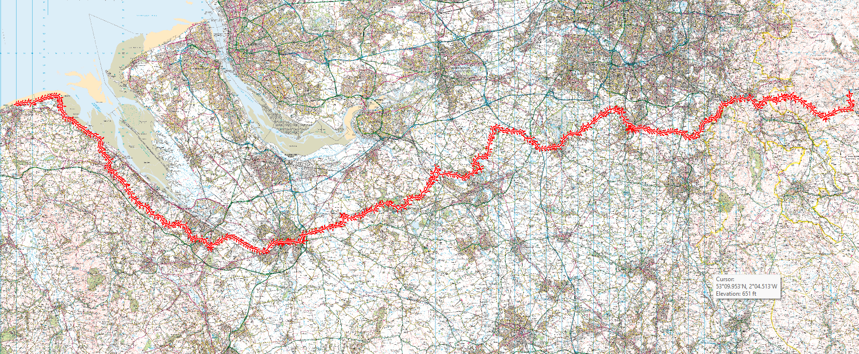
The route from Edale to Prestatyn was partly dictated by where we could find accommodation. The direction was decided by the dates on which accommodation was available. Having stayed outside Edale before the walk around Hathersage, we then walked from Edale to Rushop Hall on local paths where we stayed the first night. From Rushop Hall to Mount Famine was on the Pennine bridleway, dropping down to Peep O'Day and on to Furness Vale on local paths. We then went to Danebank via The Peak Forest Canal and on to Lyme Handley / Knott on the North Cheshire Way (NCW). From here to Bardons Clough was along the Cheshire Ring Canal Walk. Parkwood House was reached via the NCW again. Wilmslow was reached on local paths and Acton Bridge via NCW once more. We went the delightful Delamere Forest Via Delamere Way, then on to Peel Hall by Baker Way and then local paths to Swinfordmill Farm. From here to Great Barrow via the Longster Trail, then on to Hoole. There followed a bit of a road walk from Hoole to the Shropshire Union Canal then the Baker Way to cross the A 548 on to the Wales Coast Path (WCP) to Sandy Croft. A bit more road and local paths to Hawarden, then Aston and Stockholm. From there to Connah's Quay via Wepre Park and Wood. A short road walk and local paths through Connah's Quay took us to Flint Mountain and Waen y Balls. From here to Holywell was via Wat's Dyke then local paths / Pennant Walk to Stokyn Hall. From Stokyn Hall we continued on Pennant Walk to Llanach y mor then WCP to Prestatyn and end.
Edale to Rushop Hall. 4.2 miles.
An easy start, our rucksacks were delivered to our destination by our taxi service. We had
dinner in the Rambler's Inn in Edale, then promptly walked it off over the short but
interesting 4.2 miles, climbing up from Edale past Hardenclough Farm, Greenlands and Cold
Side to reach a nice ridge walk alongside Rushop Edge, then down to cross Sheffield Road and
reach Rushop Hall.
Rushop Hall to Disley. 11.1 miles.
A wet day today. It was sufficiently wet that our coffee break was taken on the move. We
followed the Pennine Bridleway to the high point of this walk, South Head at 444m. It is now
pretty much downhill to the coast! We left the bridleway near Higher Heys Farm and crossed the
A-road to Peep O'Day. A meander past Hills Farm and New Allotments, then Shedyard Clough took
us down to Furness Vale. From here we had a nice canalside walk to Disley.
Disley to Wilmslow 12.6 miles
2 hours of solid rain, though it gradually brightened. We left Disley on the North Cheshire
Way before dropping down onto the Cheshire Ring Canal Walk at Hagg Farm. You could equally
stay on the NCW until Woodend Farm. There's a lot of livestock on this section, as ever the
bullocks are very curious and tend to crowd around.
Wilmslow to Tabley. 13.9 miles.
Having destroyed my feet earlier in the year (crossing the Apennines in inappropriate
footwear) I cheated and sent my rucksack via taxi. Much better! We picked up the NCW again,
but quickly stopped for coffee at the National Trust property of Quarry Bank. The river walk
was delightful and the walk alongside Manchester Airport interesting if you like aeroplanes.
Just before Knutsford the NCW has been diverted for some building works. It is well
signposted. We left the NCW to walk alongside the A 5033 as I didn't fancy tackling the
roundabout over the M6 to get to our stop for the night in Tabley. There is a path to
Tableyvale cottages which cuts the corner to Tabley Hill Lane which was much nicer than the
A-road.
Tabley to Acton Bridge. 15.4 miles
Excellent views considering the flatness of the landscape. We followed the NCW to Arley Hall,
Great Budwoth before picking up the Cheshire Ring Canal Walk so we could look at the
Anderton Lift. We picked up the NCW again on the west side of Barnton before dropping down to
Acton Bridge and our accommodation.
Acton Bridge to Great Barrow. 13.6 miles (14 if you add the detour)
Glorious weather to start, followed by 4 hours of heavy rain. At Acton Bridge we picked up the
Delamere Way. Unfortunately it doesn't cross the railway as shown on my OS, so we had to go
to the B road and walk past the station. We took the path beside the DW to avoid that bit of
road, but the path is not well maintained. The DW takes in bits of road and track until it
gets south of Norley, rewarding us with an excellent walk through Delamere Forest and Park.
On the west side of the Forest we picked up the Baker Way to Peel Hall, then crossing to
Swinfordmill Farm to join the Longster Trail to Great Barrow.
Great Barrow to Hawarden 14.2 miles.
About a mile of this was wandering around Chester picking up surplies. Lovely sunny day. We
followed the Longster Trail to Chester before dropping down to the Baker Way alongised the
canal. Crossing the A548 put us on the Wales Coast Path on the north side of the Dee. We then
crossed to the south side at Higher Ferry House before cutting south through Sandycroft, then
past Newtown and Little Mancot before reaching Hawarden.
Hawarden to Stokyn Hall. 16.6 miles.
Long day coming today and my feet are sore again, so into the taxi goes my rucksack. A little
rain, but mostly sunny. However, wet grass defeated my boots. Hey ho. We used local paths to
leave Hawarden via Aston Hall, Stockholm and Castle Hill Farm to reach Wepre Wood which
provided some relief from poor signage, poorly maintained paths and broken stiles. We then
crossed the south side of Connah's Quay on local paths working our way to Starkey Lane and
Flint Mountain. From there we joined Wat's Dyke Way, which was very pleasant, and took us all
the way to Holywell. We then followed local paths to Stokyn Hall and our accommodation.
Stokyn Hall to Prestatyn. 11.6 miles.
From Stokyn Hall we went allong the Pennant Way down to the coast to pick up the Wales Coast
Path again. There follows a fairly uneventful walk along the coast to Prestatyn and the end.